Analyze streets before cities rebuild them.
Roadscape is active now: a startup-stage street-intelligence platform in development for cities, contractors, engineers, and residents who need road decisions backed by evidence. It is not just a video tool. The full scope is city design analysis: traffic data, crash context, housing growth, lane geometry, truck load, emergency access, pedestrian exposure, proposed schematics, cost, and performance forecasting before implementation, then proof after the change is built. With enough real data and engineering review, Roadscape can explain the design outlook, show why a plan should move forward or be reworked, and suggest better options with the evidence attached. The current pilot uses traffic footage as one evidence layer and is about 76% of the way to a defensible demo-ready pilot today. Official-grade use still requires real Fremont footage, hand-count validation, repeatable protocol, engineering review, and time.
The full scope
Roadscape is built to become the planning and evidence layer between proposed street designs, real traffic conditions, public datasets, and post-build performance.
Pre-design intelligence
Before concrete, striping, medians, turn pockets, or bike-lane changes are approved, Roadscape organizes likely traffic, safety, emergency-access, freight, maintenance, and pedestrian impacts.
Scenario performance
Compare current geometry against proposed schematics: lane width, turn radius, queue delay, new housing demand, truck mix, commute windows, cost, and expected performance change.
Design recommendations
Roadscape should not only count what happened. The end point is showing the design outlook, explaining why, and suggesting a better layout or next study step with data, assumptions, and reviewer notes attached.
Current pilot
The browser workflow is working: place a count line, run a fast scan, queue multiple clips, save the results, and export the evidence packet.
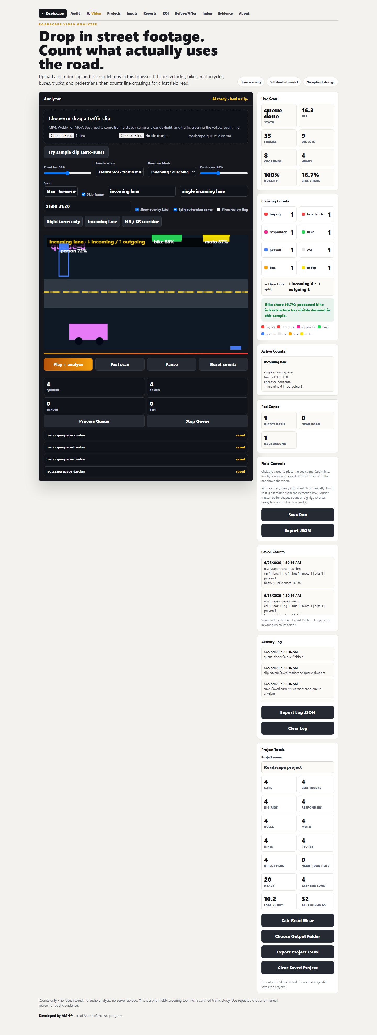
Batch queue test: four clips processed, saved, totaled, and exported.
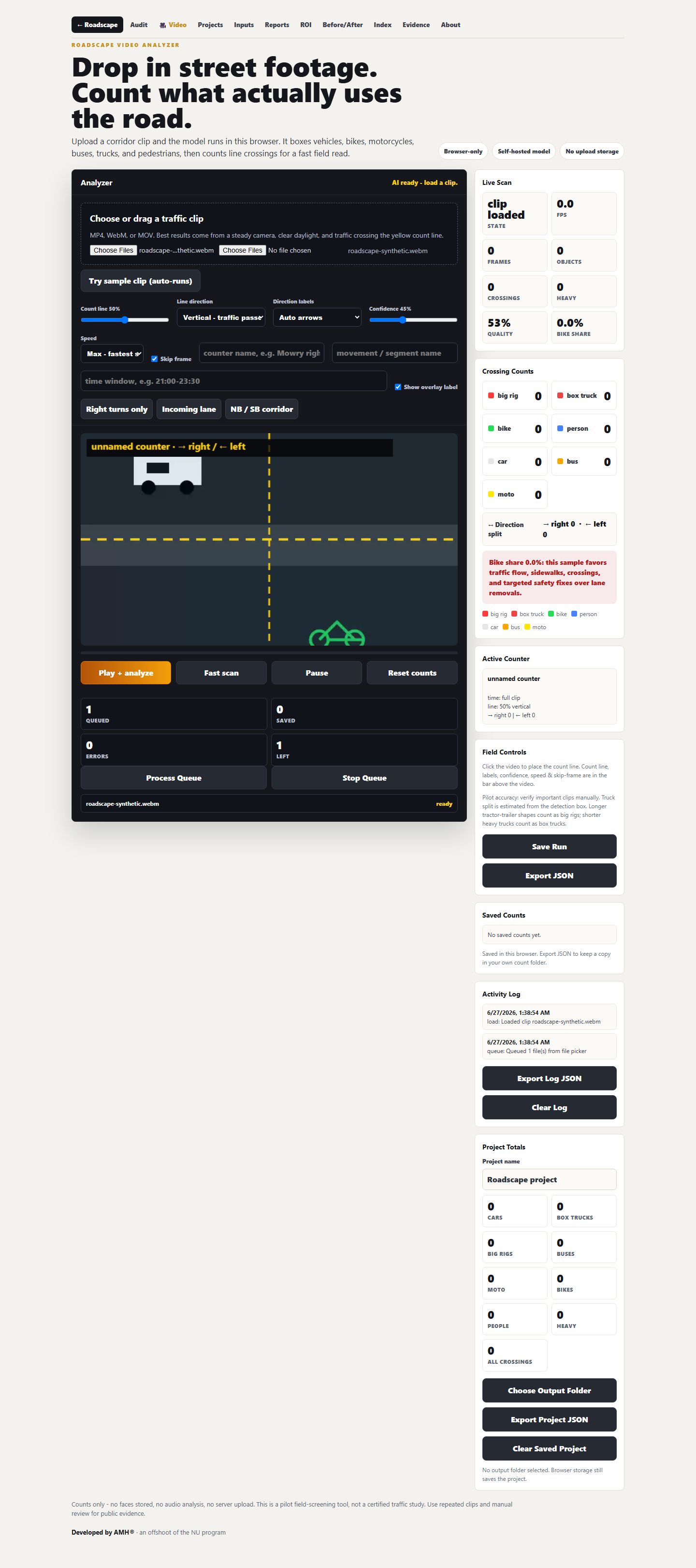
Setup stage: click-to-place count line, segment labels, direction labels, confidence, speed, and overlay controls.
Proof lab
Real test footage, Traffic Editor screenshots, segment exports, and the corridor-sim sweep are separated into their own proof page so the landing stays clean.
The browser editor, real-video sample, saved segment setup, export packet, and cycle simulation are working. The next jump is field footage plus hand-count validation.
Open proof labThe analyzer now loads the verified TW3 traffic clip as a WebM sample, with a segment workflow and report export smoke-tested from the actual UI.
Open analyzerWorking pilot
Certified-grade system
Reality checks
Food-for-thought figures that show why measurement matters. These are planning illustrations until a corridor study uses verified local counts.
If a corridor carries 25,000 vehicles/day and a redesign adds 20 seconds each, that is about 50 million seconds of driver time per year.
That same example equals roughly 13,900 hours/year. Roadscape separates raw counts from this kind of estimate so reviewers can challenge the math.
The next credibility jump is not more claims. It is a hand-counted validation set showing accuracy for cars, trucks, bikes, peds, responders, and turns.
The saleable output is one clean packet: scope, privacy, counts, charts, screenshots, caveats, engineer review lane, and recommendations.
Startup runway
Planning ranges for becoming serious enough to show an engineer, city staff, pilot customer, or early investor. These are not quotes; they are operating targets. If you want to invest, partner, or help validate the pilot, reach out here.
Open investor interest form
Enough to harden the tool and build a small validation set.
- Clip collection and hand counts
- Report template
- Basic legal/privacy docs
- Cloud and tooling
The practical "real company" runway for first city/contractor conversations.
- 50+ validation clips
- Engineer review budget
- Starter public/purchased datasets
- Insurance and contract docs
- Dashboard prototype
- Sales packet and pilot pricing
More like a true procurement-ready software/service build.
- Custom model validation
- Security and audit controls
- Multi-user projects
- Licensed data integrations
- Support, uptime, retention
- Formal pilot operations
The $100k neighborhood is a realistic target for a defensible pilot: not giant-company scale, but enough to stop looking like a hobby and start looking like a fundable infrastructure product.
Team roles
Roadscape needs practical builders and licensed reviewers. They are not the same role, and that distinction is part of making the company credible.
Construction PM / supervisor
A project manager from large builds can help with field process, jobsite reality, documentation discipline, scope, budgets, contractor language, and city-facing operations. This is a strong early teammate.
Licensed civil / traffic engineer
For official road-design conclusions, stamped recommendations, signal/geometry decisions, or pavement claims, Roadscape needs review by the properly licensed engineer for that jurisdiction.
Two-lane model
Let the PM run execution and field protocol. Let the engineer validate assumptions, limits, calculations, and recommendations. Roadscape produces the evidence packet between them.
What makes it official-grade
Code and AI are the engine. Official-grade means the result can survive review by an engineer, public works director, procurement team, contractor, insurer, or city council packet.
The product is real and running. The latest pass added the Traffic Editor workflow, real TW3 sample loading, saved segment setup, report export with counter segments, cycle-sim sweep metrics, and Claude/Codex verification logs. The remaining distance to official-grade is broader hand-counted validation, real Fremont footage, better car-vs-semi classification, browser/offline parity, repeatable study protocol, engineering review, legal/privacy packaging, and procurement-grade evidence.
Ground truth
Hand-count validation by class and movement: cars, trucks, buses, bikes, peds, responders, turns, queues, and missed detections.
Study protocol
Fixed rules for camera angle, clip length, weather, peak period, exclusions, sample windows, and before/after comparison.
Evidence chain
Source metadata, screenshots, model version, settings, confidence, manual notes, assumptions, and export hashes.
Data boundary
Written authorization, clear retention, no face identity, no surprise surveillance, no audio storage by default.
Outside datasets
Public and purchased data can layer in volumes, crashes, road geometry, permits, growth, freight routes, transit, and pavement context.
Review lane
Roadscape models and screens. Licensed review handles official redesign, signal, geometry, pavement, and liability decisions.
Procurement trust
Security docs, access control, data deletion, insurance, pilot scope, pricing, sample reports, and contract-ready language.
Build sequence
This is the practical path from prototype to leaseable software and contracted studies.
Pilot analyzer
- Upload and queue clips
- Count line setup
- Project JSON export
Validation set
- 20-50 short clips
- Hand-count baseline
- Error table by class
Report product
- Standard PDF/report
- Charts and screenshots
- Engineer review lane
City pilot
- Scope of work
- Privacy sheet
- Lease or analysis contract
Timeline after funding
The pilot is about 76% of the way to a serious first product. The latest gain came from the real-video Traffic Editor workflow, saved segment setup, report export, cycle-sim sweep, and dual-review verification. The remaining work is mostly real Fremont footage, validation depth, class-split accuracy, browser/offline parity, packaging, review, and repeatability.
Demo-ready prototype
- Analyzer works
- Queue/export works
- Manual validation export added
- Source metadata + export hashes added
- Real TW3 sample loads in the editor
- Segment setup + report export smoke-tested
- Cycle-sim sweep verified
Validation base
- 20-50 hand-counted clips
- Error rates by class
- First sample report
- Real Fremont corridor footage
Paid pilot ready
- Engineer review lane
- Privacy + SOW docs
- City/contractor demo packet
Procurement-ready v1
- Hosted dashboard
- Access controls + audit logs
- Repeatable contracted studies
"Done" is staged: 75% is enough to sell a controlled pilot; 90%+ is where it starts looking like a city-procurement product. The final 10% is ongoing validation, support, legal, and engineering review.
Validation data pipeline
More clips are not just demos. They are training data, proof data, and business leverage. Every verified file makes Roadscape better at planning, measuring, and defending corridor decisions.
What strengthens the model
- Normal corridor flow, peak periods, and low-volume streets
- Turns, queues, driveways, crosswalks, and tight geometry
- Box trucks, full rigs, buses, delivery fleets, EV-heavy traffic
- Emergency vehicles, bikes, scooters, and near-road pedestrians
How footage becomes proof
- Copy footage into a project folder with source notes
- Run fast scan and export JSON/screenshots
- Hand-check the same clip against model output
- Track misses by class, direction, movement, and confidence
Upload-copy, verify, then clean up
Process a copy, save JSON/screenshots/report outputs, verify the exports, and delete only the temporary working copy when cleanup is requested. Original footage stays untouched unless the owner explicitly chooses otherwise.
Permissioned libraries can become product leverage
If a creator, camera owner, contractor, city, or property owner allows it, Roadscape can process their footage under a clear license or paid data partnership. The point is not taking someone else's work. The point is building a permissioned platform where footage owners, Roadscape, and clients all get value from better traffic intelligence.
Open validation footage library 12 clips + channels
- Traffic validation clip 01
- Traffic validation clip 02
- Traffic validation clip 03
- Traffic validation clip 04
- Traffic validation clip 05
- Traffic validation clip 06
- Traffic validation clip 07
- Vehicle mix stress clip - class detection only
- Person detection stress clip - counts and movement only, no identity
- Traffic validation clip 08
- Traffic Heaven source channel - vehicle/class stress library
- Traffic Heaven playlists - future playlist-to-queue intake
- Playlist seed clip - queue intake test
- Traffic validation clip 09
- 101Kanan source channel - extra validation library
- Traffic validation clip 10
- Traffic validation clip 11
- Traffic validation clip 12
Private analyzer login
The live build is owner-gated while testing continues. Login opens the Roadscape video analyzer page.
Use case examples
- Run a traffic video from a corridor study.
- Count incoming/right-turn movements with named counters.
- Separate heavy trucks from normal car volume.
- Mark clips for responder or siren review without storing audio.
- Export project evidence for a report.
Owner access
Enter the same Roadscape credentials to open the private analyzer.
Built for cities, contractors, and residents who need road facts.
Roadscape is a SaaS platform first: cities, contractors, engineers, and approved operators lease the software to run permissioned traffic footage, manage projects, export evidence, and build repeatable road reports.
The service side is optional revenue: when a client does not want to operate the tool directly, Roadscape can run the permissioned study and deliver the verified analysis packet.
Roadscape is already in the build phase. The raise is for getting fully legit: validation footage, hand-count baselines, licensed data partnerships, engineer review, privacy/legal docs, insurance, dashboard hardening, and a launch-ready pilot package.
The market is practical: every city is adding housing, changing lane geometry, fighting congestion, managing emergency access, and trying to justify infrastructure spend with data.